Open Waldo in Wherobots Cloud, give it a prompt in plain language, and get a table, a map, and the code behind the answer.
Waldo is the AI agent in Wherobots Cloud for spatial data engineering, Earth observation, and geospatial analytics. You give Waldo a prompt in plain language. Waldo finds the datasets in your catalogs, writes and runs the code on WherobotsDB and RasterFlow, and returns a summary, tables, and a map. Nothing to install: Waldo runs in your browser.
Waldo is in public preview. It’s available in every Organization Edition, including the free Professional Edition trial. Features and limits may change before general availability.
Before you begin
A Wherobots Account in any Organization Edition. New Organizations start on a free Professional Edition trial. To create one, see Create a Wherobots Account.
To analyze your own data, add it to a catalog first. See Data Catalogs. Without your own data, Waldo uses Wherobots Open Data, such as Overture Maps and US Census boundaries.
If you don’t see Waldo in the left navigation, an Admin in your Organization has turned it off. Ask them to turn it on in Organization Settings > Preferences, or start with Start Your First Notebook instead.
Give Waldo a prompt
1
Open Waldo
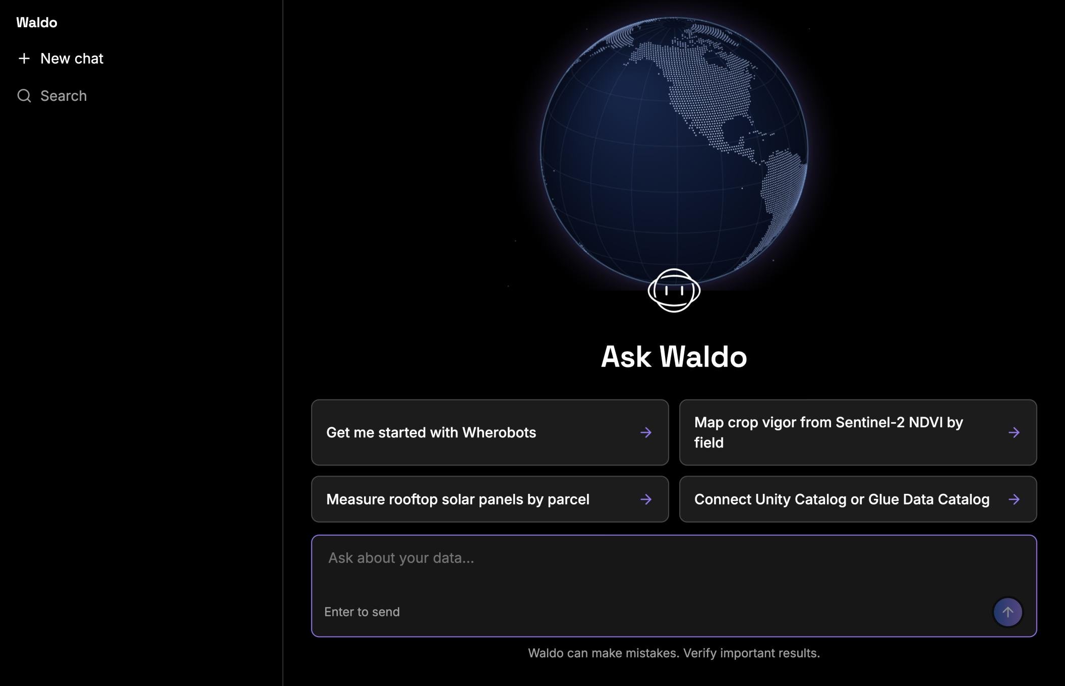
Log in to Wherobots Cloud. In the left navigation, click Waldo.
The Waldo start page
2
Write your prompt
Type a prompt in the Ask about your data box and press Enter. Name the place, what you want measured, and the output you want. Try one of these:
In King County, Washington, where are trees posing availability risks to power infrastructure? This joins a canopy height raster to power line geometries in WherobotsDB.
Which H3 level 5 cells contain the most building footprints per square kilometer? This is a global vector aggregation in WherobotsDB.
Which homes across Mesa, Arizona have rooftop solar and which don’t? RasterFlow detects panels in aerial imagery, and WherobotsDB joins them to building footprints.
3
Answer clarifying questions
If the prompt can be read more than one way, Waldo asks up to three questions and suggests a default for each. Answer them, or reply “use your defaults”.
4
Approve compute
Waldo reads catalogs and data without asking. Before it starts a runtime, runs a billed task such as a RasterFlow task, or changes a file, an approval card appears in the chat. Click Approve to continue.
5
Read the answer
The answer starts with the result in one or two sentences, then tables, a map card, and the datasets and method Waldo used. Click Open the map to view the results in Wherobots Map. Click Worked to see each step and the code behind it.
A finished answer with a map card, a summary table, and an inline map
6
Refine it
Keep asking in the same chat, for example “Show only the rural tracts” or “Save the results as GeoParquet in My Files”.
Next steps
Work with Waldo
Approvals, follow-ups, files, tips for better questions, and how to check an answer.
Waldo overview
What Waldo is best at, what it can’t do yet, and what it costs.
Schedule recurring tasks
Turn a Waldo script into a task schedule.
Start your first notebook
Write and run spatial SQL and Python yourself in a Notebook Runtime.
Was this page helpful?
{"docsConfig":{"theme":"aspen","$schema":"https://www.mintlify.com/docs.json","name":"Wherobots","colors":{"primary":"#6612c5","light":"#6612c5","dark":"#6612c5"},"logo":{"light":"https://mintcdn.com/wherobots/q2h_5BmXeWMz6JRH/logo/light.png?fit=max\u0026auto=format\u0026n=q2h_5BmXeWMz6JRH\u0026q=85\u0026s=5a1512dbd3547c3df4e8f4779a1e4cfa","dark":"https://mintcdn.com/wherobots/q2h_5BmXeWMz6JRH/logo/dark.png?fit=max\u0026auto=format\u0026n=q2h_5BmXeWMz6JRH\u0026q=85\u0026s=8d84ac8734585eb38f09b1ea4c0d8e5c","href":"/"},"favicon":"https://mintcdn.com/wherobots/q2h_5BmXeWMz6JRH/favicon.png?fit=max\u0026auto=format\u0026n=q2h_5BmXeWMz6JRH\u0026q=85\u0026s=aa88d68dcd661ed008af0d0a8c4bcd47","api":{"playground":{"display":"interactive"},"examples":{"defaults":"required","languages":["curl","python","javascript","go","java"],"prefill":true}},"appearance":{"default":"light"},"navbar":{"links":[{"href":"/changelog","label":"Changelog"},{"href":"/support","label":"Support"}],"primary":{"type":"button","label":"Open Wherobots Cloud","href":"https://cloud.wherobots.com"}},"footer":{"socials":{"linkedin":"https://www.linkedin.com/company/wherobots","x":"https://x.com/wherobots","github":"https://github.com/wherobots","youtube":"https://www.youtube.com/channel/UCFC5QjLyQ3wanshI5xUH0aw","discord":"https://sedona.apache.org/1.5.2/community/contact"},"links":[{"header":"Resources","items":[{"label":"Support","href":"/support"},{"label":"Changelog","href":"/changelog"},{"label":"Cloud availability","href":"/availability"}]},{"header":"Legal","items":[{"label":"Terms of service","href":"/terms-of-service"},{"label":"Privacy policy","href":"/privacy-policy"}]}]},"seo":{"metatags":{"canonical":"https://docs.wherobots.com","googlebot":"index, follow","robots":"index, follow","keywords":"Managed Apache Sedona, Apache Sedona, Wherobots docs, Wherobots documentation, Iceberg tables, Spatial SQL API, Wherobots Cloud Python SDK, RasterFlow, Map Matching, Spatial Data Catalog, Wherobots Airflow Provider","description":"Official Wherobots Documentation. Learn how to conduct scalable spatial analysis with WherobotsDB—the serverless cloud platform from the creators of Apache Sedona.","google-site-verification":"ERHB94F_PoM_qpM06mYclqitx8bvFFskIdV7VT8DT30","indexing":"all"}},"fonts":{"heading":{"family":"Figtree"},"body":{"family":"Figtree"}},"styling":{"codeblocks":"system","latex":false},"integrations":{"amplitude":{"apiKey":"ee314e073a5b08c12a78aef591a50bc1"},"ga4":{"measurementId":"G-D4ED50QSVC"}},"contextual":{"options":["copy","view","download-spec"],"display":"header"},"navigation":{"pages":[]}},"deployment":{"deploymentMetadataValue":{"subdomain":"wherobots","hasAudioNarration":false,"actualSubdomain":"wherobots","customDomains":["docs.wherobots.com"],"gitSource":{"type":"github","owner":"wherobots","repo":"docs","deployBranch":"main","contentDirectory":"","isPrivate":true,"mountPath":"","label":""},"feedback":{"thumbs":true},"entitlements":{"AI_CHAT":{"status":"ENABLED"},"CONTEXTUAL_FEEDBACK":{"status":"ENABLED"},"CODE_SNIPPET_FEEDBACK":{"status":"ENABLED"},"WEB_MCP":{"status":"ENABLED"},"NARRATION":{"status":"ENABLED"}},"buildId":"6afcea6848022451a15bdd6f","clientVersion":"0.0.4177","searchFilterCounts":[{"language":"default","tag":"Reference","count":1836},{"language":"default","tag":"WherobotsDB","count":879},{"language":"default","tag":"Python","count":449},{"language":"default","tag":"SQL","count":422},{"language":"default","tag":"Geometry Functions","count":267},{"language":"default","tag":"DataFrame functions","count":209},{"language":"default","tag":"GeoPandas API","count":159},{"language":"default","tag":"GeoSeries","count":130},{"language":"default","tag":"Raster Functions","count":109},{"language":"default","tag":"Accessors","count":94}]},"assistantConfig":{"enableAskAiButton":true,"enableAskAiSearchBar":false},"basePath":"","hasChatPermissions":true,"hasWebMcpPermissions":true,"toggles":[{"name":"kill-isr","enabled":true,"variant":{"name":"disabled","enabled":false,"feature_enabled":true},"impressionData":false},{"name":"custom-rbac-roles","enabled":true,"variant":{"name":"disabled","enabled":false,"feature_enabled":true},"impressionData":false},{"name":"agent-mintlify-slack","enabled":true,"variant":{"name":"disabled","enabled":false,"feature_enabled":true},"impressionData":false},{"name":"agent-integrations-settings","enabled":true,"variant":{"name":"disabled","enabled":false,"feature_enabled":true},"impressionData":false},{"name":"rbac-expansion","enabled":true,"variant":{"name":"disabled","enabled":false,"feature_enabled":true},"impressionData":false},{"name":"automations-pr-grouping","enabled":true,"variant":{"name":"disabled","enabled":false,"feature_enabled":true},"impressionData":false},{"name":"custom-prefix","enabled":true,"variant":{"name":"disabled","enabled":false,"feature_enabled":true},"impressionData":false},{"name":"analytics-v7","enabled":true,"variant":{"name":"disabled","enabled":false,"feature_enabled":true},"impressionData":false},{"name":"user-flows-analytics","enabled":true,"variant":{"name":"disabled","enabled":false,"feature_enabled":true},"impressionData":false},{"name":"no-publish-flow","enabled":true,"variant":{"name":"disabled","enabled":false,"feature_enabled":true},"impressionData":false},{"name":"workos-onboarding","enabled":true,"variant":{"name":"disabled","enabled":false,"feature_enabled":true},"impressionData":false},{"name":"snapshot-serving-live","enabled":true,"variant":{"name":"disabled","enabled":false,"feature_enabled":true},"impressionData":false},{"name":"stripTemperatureMiddleware","enabled":true,"variant":{"name":"disabled","enabled":false,"feature_enabled":true},"impressionData":false},{"name":"support-platform-pylon-zendesk","enabled":true,"variant":{"name":"disabled","enabled":false,"feature_enabled":true},"impressionData":false},{"name":"snapshot-serving","enabled":true,"variant":{"name":"disabled","enabled":false,"feature_enabled":true},"impressionData":false},{"name":"instant-rollback","enabled":true,"variant":{"name":"disabled","enabled":false,"feature_enabled":true},"impressionData":false},{"name":"granular-notifications-server","enabled":true,"variant":{"name":"disabled","enabled":false,"feature_enabled":true},"impressionData":false},{"name":"granular-notifications","enabled":true,"variant":{"name":"disabled","enabled":false,"feature_enabled":true},"impressionData":false},{"name":"automations-fable","enabled":true,"variant":{"name":"disabled","enabled":false,"feature_enabled":true},"impressionData":false},{"name":"fixed-ai-action-pricing","enabled":true,"variant":{"name":"disabled","enabled":false,"feature_enabled":true},"impressionData":false},{"name":"automation-resolve-merge-conflict","enabled":true,"variant":{"name":"disabled","enabled":false,"feature_enabled":true},"impressionData":false},{"name":"scoped-publishing","enabled":true,"variant":{"name":"disabled","enabled":false,"feature_enabled":true},"impressionData":false},{"name":"mintql","enabled":true,"variant":{"name":"disabled","enabled":false,"feature_enabled":true},"impressionData":false},{"name":"page-level-analytics","enabled":true,"variant":{"name":"disabled","enabled":false,"feature_enabled":true},"impressionData":false},{"name":"editor-version-history-v2","enabled":true,"variant":{"name":"disabled","enabled":false,"feature_enabled":true},"impressionData":false},{"name":"billing-page-v2","enabled":true,"variant":{"name":"disabled","enabled":false,"feature_enabled":true},"impressionData":false},{"name":"full-page-search","enabled":true,"variant":{"name":"disabled","enabled":false,"feature_enabled":true},"impressionData":false},{"name":"workspace-projects","enabled":true,"variant":{"name":"disabled","enabled":false,"feature_enabled":true},"impressionData":false},{"name":"assistant-v5","enabled":true,"variant":{"name":"disabled","enabled":false,"feature_enabled":true},"impressionData":false},{"name":"fork-pr-previews","enabled":true,"variant":{"name":"disabled","enabled":false,"feature_enabled":true},"impressionData":false},{"name":"revalidation-jwt","enabled":true,"variant":{"name":"disabled","enabled":false,"feature_enabled":true},"impressionData":false},{"name":"workos-sso-scim","enabled":true,"variant":{"name":"disabled","enabled":false,"feature_enabled":true},"impressionData":false},{"name":"hobby-abuse-scan","enabled":true,"variant":{"name":"disabled","enabled":false,"feature_enabled":true},"impressionData":false},{"name":"dashboard-inbox","enabled":true,"variant":{"name":"disabled","enabled":false,"feature_enabled":true},"impressionData":false},{"name":"workos-signup","enabled":true,"variant":{"name":"disabled","enabled":false,"feature_enabled":true},"impressionData":false},{"name":"turbopuffer-dual-write","enabled":true,"variant":{"name":"disabled","enabled":false,"feature_enabled":true},"impressionData":false},{"name":"workos-enabled","enabled":true,"variant":{"name":"disabled","enabled":false,"feature_enabled":true},"impressionData":false},{"name":"approve-review-flow","enabled":true,"variant":{"name":"disabled","enabled":false,"feature_enabled":true},"impressionData":false},{"name":"editor-metadata","enabled":true,"variant":{"name":"disabled","enabled":false,"feature_enabled":true},"impressionData":false},{"name":"sso-setup-deadline-banner","enabled":true,"variant":{"name":"disabled","enabled":false,"feature_enabled":true},"impressionData":false},{"name":"turbopuffer-serve","enabled":true,"variant":{"name":"disabled","enabled":false,"feature_enabled":true},"impressionData":false},{"name":"live-agents","enabled":true,"variant":{"name":"disabled","enabled":false,"feature_enabled":true},"impressionData":false},{"name":"starter-pricing","enabled":true,"variant":{"name":"treatment","enabled":true,"payload":{"type":"string","value":"treatment"},"feature_enabled":true},"impressionData":false},{"name":"llms-txt-v2","enabled":true,"variant":{"name":"disabled","enabled":false,"feature_enabled":true},"impressionData":false},{"name":"wildcard-email-auth","enabled":true,"variant":{"name":"disabled","enabled":false,"feature_enabled":true},"impressionData":false}],"googleFontsInlined":true},"customCss":[],"page":{"pagePath":"get-started/waldo-quickstart","slug":"/get-started/waldo-quickstart","pageMetadata":{"title":"Give Waldo your first prompt","description":"Open Waldo in Wherobots Cloud, give it a prompt in plain language, and get a table, a map, and the code behind the answer.","sidebarTitle":"Give Waldo a prompt","href":"/get-started/waldo-quickstart"},"description":{"compiledSource":"\"use strict\";\nconst {jsx: _jsx} = arguments[0];\nconst {useMDXComponents: _provideComponents} = arguments[0];\nfunction _createMdxContent(props) {\n const _components = {\n p: \"p\",\n ..._provideComponents(),\n ...props.components\n };\n return _jsx(_components.p, {\n children: \"Open Waldo in Wherobots Cloud, give it a prompt in plain language, and get a table, a map, and the code behind the answer.\"\n });\n}\nfunction MDXContent(props = {}) {\n const {wrapper: MDXLayout} = {\n ..._provideComponents(),\n ...props.components\n };\n return MDXLayout ? _jsx(MDXLayout, {\n ...props,\n children: _jsx(_createMdxContent, {\n ...props\n })\n }) : _createMdxContent(props);\n}\nreturn {\n default: MDXContent\n};\n","frontmatter":{},"scope":{}},"pageType":"default","mdx":{"mdxSource":{"compiledSource":"\"use strict\";const{Fragment:_Fragment,jsx:_jsx,jsxs:_jsxs}=arguments[0];const{useMDXComponents:_provideComponents}=arguments[0];function _createMdxContent(props){const _components={a:`a`,li:`li`,p:`p`,strong:`strong`,ul:`ul`,..._provideComponents(),...props.components},{Card,CardGroup,Frame,Heading,Note,OptimizedImage,Step,Steps,Tip}=_components;if(!Card)_missingMdxReference(`Card`,true);if(!CardGroup)_missingMdxReference(`CardGroup`,true);if(!Frame)_missingMdxReference(`Frame`,true);if(!Heading)_missingMdxReference(`Heading`,true);if(!Note)_missingMdxReference(`Note`,true);if(!OptimizedImage)_missingMdxReference(`OptimizedImage`,true);if(!Step)_missingMdxReference(`Step`,true);if(!Steps)_missingMdxReference(`Steps`,true);if(!Tip)_missingMdxReference(`Tip`,true);return _jsxs(_Fragment,{children:[_jsxs(_components.p,{children:[_jsx(_components.strong,{children:`Waldo`}),` is the AI agent in Wherobots Cloud for spatial data engineering, Earth observation, and geospatial analytics. You give Waldo a prompt in plain language. Waldo finds the datasets in your catalogs, writes and runs the code on WherobotsDB and RasterFlow, and returns a summary, tables, and a map. Nothing to install: Waldo runs in your browser.`]}),`\n`,_jsx(Note,{children:_jsxs(_components.p,{children:[_jsx(_components.strong,{children:`Waldo is in public preview.`}),` It’s available in every Organization Edition, including the free Professional Edition trial. Features and limits may change before general availability.`]})}),`\n`,_jsx(Heading,{level:`2`,id:`before-you-begin`,children:`Before you begin`}),`\n`,_jsxs(_components.ul,{children:[`\n`,_jsxs(_components.li,{children:[`A Wherobots Account in any Organization Edition. New Organizations start on a free Professional Edition trial. To create one, see `,_jsx(_components.a,{href:`/get-started/wherobots-cloud/create-account`,children:`Create a Wherobots Account`}),`.`]}),`\n`,_jsxs(_components.li,{children:[`To analyze your own data, add it to a catalog first. See `,_jsx(_components.a,{href:`/get-started/initial-storage/data-hub`,children:`Data Catalogs`}),`. Without your own data, Waldo uses Wherobots Open Data, such as Overture Maps and US Census boundaries.`]}),`\n`]}),`\n`,_jsx(Tip,{children:_jsxs(_components.p,{children:[`If you don’t see `,_jsx(_components.strong,{children:`Waldo`}),` in the left navigation, an Admin in your Organization has turned it off. Ask them to turn it on in `,_jsx(_components.strong,{children:`Organization Settings`}),` > `,_jsx(_components.strong,{children:`Preferences`}),`, or start with `,_jsx(_components.a,{href:`/get-started/wherobots-cloud/start-notebook`,children:`Start Your First Notebook`}),` instead.`]})}),`\n`,_jsx(Heading,{level:`2`,id:`give-waldo-a-prompt`,children:`Give Waldo a prompt`}),`\n`,_jsxs(Steps,{children:[_jsxs(Step,{title:`Open Waldo`,children:[_jsxs(_components.p,{children:[`Log in to `,_jsx(_components.a,{href:`https://cloud.wherobots.com/`,children:`Wherobots Cloud`}),`. In the left navigation, click `,_jsx(_components.strong,{children:`Waldo`}),`.`]}),_jsx(Frame,{caption:`The Waldo start page`,children:_jsx(OptimizedImage,{src:`https://mintcdn.com/wherobots/pIL7XBACyDQjslj7/images/develop/waldo/empty-state.png?fit=max\u0026auto=format\u0026n=pIL7XBACyDQjslj7\u0026q=85\u0026s=e50f016a1fc42e09373557f39a836b30`,alt:`The Ask Waldo page with suggested prompts and the Ask about your data box`,\"data-og-width\":`2112`,width:`2112`,\"data-og-height\":`1360`,height:`1360`,\"data-path\":`images/develop/waldo/empty-state.png`,\"data-optimize\":`true`,\"data-opv\":`3`,srcset:`https://mintcdn.com/wherobots/pIL7XBACyDQjslj7/images/develop/waldo/empty-state.png?w=280\u0026fit=max\u0026auto=format\u0026n=pIL7XBACyDQjslj7\u0026q=85\u0026s=5c6fb800b0a5fb4efb27bb66f24edf2c 280w, https://mintcdn.com/wherobots/pIL7XBACyDQjslj7/images/develop/waldo/empty-state.png?w=560\u0026fit=max\u0026auto=format\u0026n=pIL7XBACyDQjslj7\u0026q=85\u0026s=428dec983f0f2a0e6c905eb5e7898120 560w, https://mintcdn.com/wherobots/pIL7XBACyDQjslj7/images/develop/waldo/empty-state.png?w=840\u0026fit=max\u0026auto=format\u0026n=pIL7XBACyDQjslj7\u0026q=85\u0026s=49324e7658531b9d2422a5bf99de2b89 840w, https://mintcdn.com/wherobots/pIL7XBACyDQjslj7/images/develop/waldo/empty-state.png?w=1100\u0026fit=max\u0026auto=format\u0026n=pIL7XBACyDQjslj7\u0026q=85\u0026s=10f902173e4b2e2e074838d8adfbfc8c 1100w, https://mintcdn.com/wherobots/pIL7XBACyDQjslj7/images/develop/waldo/empty-state.png?w=1650\u0026fit=max\u0026auto=format\u0026n=pIL7XBACyDQjslj7\u0026q=85\u0026s=e55d0c8aabd168d99061bf2ee1b83dc5 1650w, https://mintcdn.com/wherobots/pIL7XBACyDQjslj7/images/develop/waldo/empty-state.png?w=2500\u0026fit=max\u0026auto=format\u0026n=pIL7XBACyDQjslj7\u0026q=85\u0026s=986c11c9cad312d9935e4e7eaf7be899 2500w`})})]}),_jsxs(Step,{title:`Write your prompt`,children:[_jsxs(_components.p,{children:[`Type a prompt in the `,_jsx(_components.strong,{children:`Ask about your data`}),` box and press `,_jsx(_components.strong,{children:`Enter`}),`. Name the place, what you want measured, and the output you want. Try one of these:`]}),_jsxs(_components.ul,{children:[`\n`,_jsx(_components.li,{children:`In King County, Washington, where are trees posing availability risks to power infrastructure? This joins a canopy height raster to power line geometries in WherobotsDB.`}),`\n`,_jsx(_components.li,{children:`Which H3 level 5 cells contain the most building footprints per square kilometer? This is a global vector aggregation in WherobotsDB.`}),`\n`,_jsx(_components.li,{children:`Which homes across Mesa, Arizona have rooftop solar and which don’t? RasterFlow detects panels in aerial imagery, and WherobotsDB joins them to building footprints.`}),`\n`]})]}),_jsx(Step,{title:`Answer clarifying questions`,children:_jsx(_components.p,{children:`If the prompt can be read more than one way, Waldo asks up to three questions and suggests a default for each. Answer them, or reply “use your defaults”.`})}),_jsx(Step,{title:`Approve compute`,children:_jsxs(_components.p,{children:[`Waldo reads catalogs and data without asking. Before it starts a runtime, runs a billed task such as a RasterFlow task, or changes a file, an approval card appears in the chat. Click `,_jsx(_components.strong,{children:`Approve`}),` to continue.`]})}),_jsxs(Step,{title:`Read the answer`,children:[_jsxs(_components.p,{children:[`The answer starts with the result in one or two sentences, then tables, a map card, and the datasets and method Waldo used. Click `,_jsx(_components.strong,{children:`Open the map`}),` to view the results in Wherobots Map. Click `,_jsx(_components.strong,{children:`Worked`}),` to see each step and the code behind it.`]}),_jsx(Frame,{caption:`A finished answer with a map card, a summary table, and an inline map`,children:_jsx(OptimizedImage,{src:`https://mintcdn.com/wherobots/cznO35op89Akau7K/images/develop/waldo/answer-map-card.png?fit=max\u0026auto=format\u0026n=cznO35op89Akau7K\u0026q=85\u0026s=f54d84a7abb15ecea49a49bfbae75d90`,alt:`A Waldo answer for Mesa, Arizona rooftop solar, with a map card, a summary table, and an inline map`,\"data-og-width\":`1364`,width:`1364`,\"data-og-height\":`1582`,height:`1582`,\"data-path\":`images/develop/waldo/answer-map-card.png`,\"data-optimize\":`true`,\"data-opv\":`3`,srcset:`https://mintcdn.com/wherobots/cznO35op89Akau7K/images/develop/waldo/answer-map-card.png?w=280\u0026fit=max\u0026auto=format\u0026n=cznO35op89Akau7K\u0026q=85\u0026s=ce963f96babf2e2538f1dd6ea67d73ca 280w, https://mintcdn.com/wherobots/cznO35op89Akau7K/images/develop/waldo/answer-map-card.png?w=560\u0026fit=max\u0026auto=format\u0026n=cznO35op89Akau7K\u0026q=85\u0026s=1147733d16c95ee5f5dd6f947cfac40e 560w, https://mintcdn.com/wherobots/cznO35op89Akau7K/images/develop/waldo/answer-map-card.png?w=840\u0026fit=max\u0026auto=format\u0026n=cznO35op89Akau7K\u0026q=85\u0026s=cf7e9042796a34599003c3faf5136aed 840w, https://mintcdn.com/wherobots/cznO35op89Akau7K/images/develop/waldo/answer-map-card.png?w=1100\u0026fit=max\u0026auto=format\u0026n=cznO35op89Akau7K\u0026q=85\u0026s=50a749263e23880a70304742b79837d1 1100w, https://mintcdn.com/wherobots/cznO35op89Akau7K/images/develop/waldo/answer-map-card.png?w=1650\u0026fit=max\u0026auto=format\u0026n=cznO35op89Akau7K\u0026q=85\u0026s=693938e34d126e08950641308aa8c736 1650w, https://mintcdn.com/wherobots/cznO35op89Akau7K/images/develop/waldo/answer-map-card.png?w=2500\u0026fit=max\u0026auto=format\u0026n=cznO35op89Akau7K\u0026q=85\u0026s=838876c2199207297ca1d39667c2891c 2500w`})})]}),_jsx(Step,{title:`Refine it`,children:_jsx(_components.p,{children:`Keep asking in the same chat, for example “Show only the rural tracts” or “Save the results as GeoParquet in My Files”.`})})]}),`\n`,_jsx(Heading,{level:`2`,id:`next-steps`,children:`Next steps`}),`\n`,_jsxs(CardGroup,{cols:2,children:[_jsx(Card,{title:`Work with Waldo`,icon:`messages`,href:`/develop/waldo/use-waldo`,children:_jsx(_components.p,{children:`Approvals, follow-ups, files, tips for better questions, and how to check an answer.`})}),_jsx(Card,{title:`Waldo overview`,icon:`sparkles`,href:`/develop/waldo/overview`,children:_jsx(_components.p,{children:`What Waldo is best at, what it can’t do yet, and what it costs.`})}),_jsx(Card,{title:`Schedule recurring tasks`,icon:`clock`,href:`/develop/waldo/schedules`,children:_jsx(_components.p,{children:`Turn a Waldo script into a task schedule.`})}),_jsx(Card,{title:`Start your first notebook`,icon:`book-open`,href:`/get-started/wherobots-cloud/start-notebook`,children:_jsx(_components.p,{children:`Write and run spatial SQL and Python yourself in a Notebook Runtime.`})})]})]})}function MDXContent(props={}){const{wrapper:MDXLayout}={..._provideComponents(),...props.components};return MDXLayout?_jsx(MDXLayout,{...props,children:_jsx(_createMdxContent,{...props})}):_createMdxContent(props)}return{default:MDXContent};function _missingMdxReference(id,component){throw new Error(`Expected `+(component?`component`:`object`)+\" `\"+id+\"` to be defined: you likely forgot to import, pass, or provide it.\")}","frontmatter":{},"scope":{"codeStyling":"system","config":{},"pageMetadata":{"title":"Give Waldo your first prompt","description":"Open Waldo in Wherobots Cloud, give it a prompt in plain language, and get a table, a map, and the code behind the answer.","sidebarTitle":"Give Waldo a prompt","href":"/get-started/waldo-quickstart"}}},"mdxSourceWithNoJs":null},"mdxExtracts":{"tableOfContents":[{"title":"Before you begin","slug":"before-you-begin","depth":2,"children":[]},{"title":"Give Waldo a prompt","slug":"give-waldo-a-prompt","depth":2,"children":[]},{"title":"Next steps","slug":"next-steps","depth":2,"children":[]}],"codeExamples":{}},"jsLinks":["/_mintlify/custom/wherobots/af65d87e5cbbfaa8/redirect-default-hosts.js"],"subdomain":"wherobots","siteName":"Wherobots","title":"Give Waldo your first prompt - Wherobots","navMaps":{"firstHrefInVersion":{},"firstHrefInLanguage":{}},"lastModified":"2026-11-17T23:45:31.924Z","originalFileLocation":"get-started/waldo-quickstart.mdx"},"headHtml":"\u003cscript data-mint-head>(function(){var d=document.documentElement,p=null;if(!p){try{p=localStorage.getItem(\"isDarkMode\")}catch(e){}if(p==='true')p='dark';else if(p==='false')p='light';if(p!=='light'\u0026\u0026p!=='dark'\u0026\u0026p!=='system')p=\"light\"}var r=p==='system'?(matchMedia(\"(prefers-color-scheme: dark)\").matches?'dark':'light'):p;d.classList.remove(r==='dark'?'light':'dark');d.classList.add(r);d.setAttribute(\"data-theme-preference\",p)})();\u003c/script>\u003cmeta data-mint-head name=\"description\" content=\"Open Waldo in Wherobots Cloud, give it a prompt in plain language, and get a table, a map, and the code behind the answer.\">\u003cmeta data-mint-head name=\"keywords\" content=\"Managed Apache Sedona, Apache Sedona, Wherobots docs, Wherobots documentation, Iceberg tables, Spatial SQL API, Wherobots Cloud Python SDK, RasterFlow, Map Matching, Spatial Data Catalog, Wherobots Airflow Provider\">\u003cmeta data-mint-head name=\"application-name\" content=\"Wherobots\">\u003cmeta data-mint-head name=\"generator\" content=\"Mintlify\">\u003cmeta data-mint-head name=\"robots\" content=\"index, follow\">\u003clink data-mint-head rel=\"icon\" type=\"image/png\" sizes=\"192x192\" href=\"/mintlify-assets/_mintlify/favicons/wherobots/pvz71JLOQQJkmmD3/_generated/favicon/android-chrome-192x192.png\" media=\"(prefers-color-scheme: light)\">\u003clink data-mint-head rel=\"apple-touch-icon\" type=\"image/png\" sizes=\"180x180\" href=\"/mintlify-assets/_mintlify/favicons/wherobots/pvz71JLOQQJkmmD3/_generated/favicon/apple-touch-icon.png\">\u003clink data-mint-head rel=\"icon\" type=\"image/png\" sizes=\"16x16\" href=\"/mintlify-assets/_mintlify/favicons/wherobots/pvz71JLOQQJkmmD3/_generated/favicon/favicon-16x16.png\" media=\"(prefers-color-scheme: light)\">\u003clink data-mint-head rel=\"icon\" type=\"image/png\" sizes=\"32x32\" href=\"/mintlify-assets/_mintlify/favicons/wherobots/pvz71JLOQQJkmmD3/_generated/favicon/favicon-32x32.png\" media=\"(prefers-color-scheme: light)\">\u003clink data-mint-head rel=\"shortcut icon\" type=\"image/x-icon\" href=\"/mintlify-assets/_mintlify/favicons/wherobots/pvz71JLOQQJkmmD3/_generated/favicon/favicon.ico\" media=\"(prefers-color-scheme: light)\">\u003clink data-mint-head rel=\"icon\" type=\"image/png\" sizes=\"192x192\" href=\"/mintlify-assets/_mintlify/favicons/wherobots/pvz71JLOQQJkmmD3/_generated/favicon-dark/android-chrome-192x192.png\" media=\"(prefers-color-scheme: dark)\">\u003clink data-mint-head rel=\"icon\" type=\"image/png\" sizes=\"16x16\" href=\"/mintlify-assets/_mintlify/favicons/wherobots/pvz71JLOQQJkmmD3/_generated/favicon-dark/favicon-16x16.png\" media=\"(prefers-color-scheme: dark)\">\u003clink data-mint-head rel=\"icon\" type=\"image/png\" sizes=\"32x32\" href=\"/mintlify-assets/_mintlify/favicons/wherobots/pvz71JLOQQJkmmD3/_generated/favicon-dark/favicon-32x32.png\" media=\"(prefers-color-scheme: dark)\">\u003clink data-mint-head rel=\"shortcut icon\" type=\"image/x-icon\" href=\"/mintlify-assets/_mintlify/favicons/wherobots/pvz71JLOQQJkmmD3/_generated/favicon-dark/favicon.ico\" media=\"(prefers-color-scheme: dark)\">\u003cmeta data-mint-head property=\"og:title\" content=\"Give Waldo your first prompt - Wherobots\">\u003cmeta data-mint-head property=\"og:description\" content=\"Open Waldo in Wherobots Cloud, give it a prompt in plain language, and get a table, a map, and the code behind the answer.\">\u003cmeta data-mint-head property=\"og:site_name\" content=\"Wherobots\">\u003cmeta data-mint-head property=\"og:url\" content=\"https://docs.wherobots.com/get-started/waldo-quickstart\">\u003cmeta data-mint-head property=\"og:type\" content=\"website\">\u003cmeta data-mint-head property=\"og:image\" content=\"https://wherobots.mintlify.site/_mintlify/api/og/v2?division=Get+started\u0026amp;title=Give+Waldo+your+first+prompt\u0026amp;description=Open+Waldo+in+Wherobots+Cloud%2C+give+it+a+prompt+in+plain+language%2C+and+get+a+table%2C+a+map%2C+and+the+code+behind+the+answer.\u0026amp;theme=fbe4d6d3646e3c93cd4b4042\u0026amp;signature=4a6d4cdf99cb88eaa50f1ad1f4d5f1697ed2566f4fdb08f40e8b1824bf2fd481\">\u003cmeta data-mint-head property=\"og:image:width\" content=\"1200\">\u003cmeta data-mint-head property=\"og:image:height\" content=\"630\">\u003cmeta data-mint-head name=\"twitter:card\" content=\"summary_large_image\">\u003cmeta data-mint-head name=\"twitter:title\" content=\"Give Waldo your first prompt - Wherobots\">\u003cmeta data-mint-head name=\"twitter:description\" content=\"Open Waldo in Wherobots Cloud, give it a prompt in plain language, and get a table, a map, and the code behind the answer.\">\u003cmeta data-mint-head name=\"twitter:image\" content=\"https://wherobots.mintlify.site/_mintlify/api/og/v2?division=Get+started\u0026amp;title=Give+Waldo+your+first+prompt\u0026amp;description=Open+Waldo+in+Wherobots+Cloud%2C+give+it+a+prompt+in+plain+language%2C+and+get+a+table%2C+a+map%2C+and+the+code+behind+the+answer.\u0026amp;theme=fbe4d6d3646e3c93cd4b4042\u0026amp;signature=4a6d4cdf99cb88eaa50f1ad1f4d5f1697ed2566f4fdb08f40e8b1824bf2fd481\">\u003cmeta data-mint-head name=\"twitter:image:width\" content=\"1200\">\u003cmeta data-mint-head name=\"twitter:image:height\" content=\"630\">\u003cmeta data-mint-head name=\"msapplication-config\" content=\"/mintlify-assets/_mintlify/favicons/wherobots/pvz71JLOQQJkmmD3/_generated/favicon/browserconfig.xml\">\u003cmeta data-mint-head name=\"apple-mobile-web-app-title\" content=\"Wherobots\">\u003cmeta data-mint-head name=\"msapplication-TileColor\" content=\"#6612c5\">\u003cmeta data-mint-head name=\"googlebot\" content=\"index, follow\">\u003cmeta data-mint-head name=\"google-site-verification\" content=\"ERHB94F_PoM_qpM06mYclqitx8bvFFskIdV7VT8DT30\">\u003cmeta data-mint-head name=\"indexing\" content=\"all\">\u003clink data-mint-head rel=\"canonical\" href=\"https://docs.wherobots.com/get-started/waldo-quickstart\">\u003clink data-mint-head rel=\"alternate\" type=\"application/xml\" href=\"/sitemap.xml\">\u003clink data-mint-head rel=\"alternate\" type=\"text/markdown\" href=\"/get-started/waldo-quickstart.md\">\u003cscript data-mint-head type=\"application/ld+json\">{\"@context\":\"https://schema.org\",\"@graph\":[{\"@type\":\"Organization\",\"@id\":\"https://docs.wherobots.com/#organization\",\"name\":\"Wherobots\",\"url\":\"https://docs.wherobots.com\",\"logo\":{\"@type\":\"ImageObject\",\"url\":\"https://mintcdn.com/wherobots/q2h_5BmXeWMz6JRH/logo/light.png?fit=max\u0026auto=format\u0026n=q2h_5BmXeWMz6JRH\u0026q=85\u0026s=5a1512dbd3547c3df4e8f4779a1e4cfa\"}},{\"@type\":\"WebSite\",\"@id\":\"https://docs.wherobots.com#website\",\"name\":\"Wherobots\",\"url\":\"https://docs.wherobots.com\",\"publisher\":{\"@id\":\"https://docs.wherobots.com/#organization\"}},{\"@type\":\"WebPage\",\"@id\":\"https://docs.wherobots.com/get-started/waldo-quickstart#webpage\",\"url\":\"https://docs.wherobots.com/get-started/waldo-quickstart\",\"name\":\"Give Waldo your first prompt\",\"description\":\"Open Waldo in Wherobots Cloud, give it a prompt in plain language, and get a table, a map, and the code behind the answer.\",\"dateModified\":\"2026-11-17T23:45:31.924Z\",\"isPartOf\":{\"@id\":\"https://docs.wherobots.com#website\"},\"breadcrumb\":{\"@id\":\"https://docs.wherobots.com/get-started/waldo-quickstart#breadcrumb\"}},{\"@type\":\"BreadcrumbList\",\"@id\":\"https://docs.wherobots.com/get-started/waldo-quickstart#breadcrumb\",\"itemListElement\":[{\"@type\":\"ListItem\",\"position\":1,\"name\":\"Get started\",\"item\":\"https://docs.wherobots.com\"},{\"@type\":\"ListItem\",\"position\":2,\"name\":\"Give Waldo your first prompt\",\"item\":\"https://docs.wherobots.com/get-started/waldo-quickstart\"}]},{\"@type\":[\"Article\",\"TechArticle\"],\"@id\":\"https://docs.wherobots.com/get-started/waldo-quickstart#article\",\"headline\":\"Give Waldo your first prompt\",\"name\":\"Give Waldo your first prompt\",\"description\":\"Open Waldo in Wherobots Cloud, give it a prompt in plain language, and get a table, a map, and the code behind the answer.\",\"url\":\"https://docs.wherobots.com/get-started/waldo-quickstart\",\"mainEntityOfPage\":{\"@id\":\"https://docs.wherobots.com/get-started/waldo-quickstart#webpage\"},\"dateModified\":\"2026-11-17T23:45:31.924Z\",\"publisher\":{\"@id\":\"https://docs.wherobots.com/#organization\"},\"isPartOf\":{\"@id\":\"https://docs.wherobots.com#website\"}}]}\u003c/script>\u003cscript data-mint-head type=\"application/ld+json\">{\"@context\":\"https://schema.org\",\"@type\":\"WebSite\",\"name\":\"Wherobots\",\"publisher\":{\"@type\":\"Organization\",\"name\":\"Wherobots\"},\"provider\":{\"@type\":\"Organization\",\"name\":\"Mintlify\",\"url\":\"https://mintlify.com\"}}\u003c/script>","agentPointerHref":"/get-started/waldo-quickstart.md","siteName":"Wherobots","nav":{"global":null,"tabs":[{"tab":"Get started","pages":[{"group":"Get started","root":{"title":"Wherobots documentation","sidebarTitle":"Overview","mode":"wide","href":""},"pages":[{"title":"Create a Wherobots Account","description":"Create a Wherobots Account to access Wherobots Cloud and its suite of geospatial data processing and analytics tools.","href":"/get-started/wherobots-cloud/create-account"},{"title":"Give Waldo your first prompt","sidebarTitle":"Give Waldo a prompt","href":"/get-started/waldo-quickstart"},{"group":"Concepts","icon":"compass","expanded":false,"pages":[{"title":"Wherobots Platform Overview","description":"Learn how WherobotsDB and RasterFlow, the two Wherobots products, work together in Wherobots Cloud to process spatial data and Earth imagery","sidebarTitle":"Platform Overview","href":"/get-started/wherobots-fundamentals/platform-overview"},{"title":"What is Apache Sedona?","href":"/apache-sedona"},{"title":"Introduction to Spatial Data","href":"/get-started/wherobots-fundamentals/intro-to-spatial-data"},{"title":"Glossary: Key Spatial Terms and Concepts","sidebarTitle":"Key Spatial Terms and Concepts","href":"/get-started/wherobots-fundamentals/glossary"}]}]}]},{"tab":"Build \u0026 Deploy","pages":[{"title":"Build \u0026 Deploy","href":"/develop/overview"}]},{"tab":"Spatial Data Engineering","pages":[{"title":"Spatial Data Engineering","href":"/data-engineering"}]},{"tab":"AI for Earth","pages":[{"title":"AI for Earth","href":"/ai-for-earth"}]},{"tab":"Reference","pages":[{"title":"Reference","href":"/reference/overview"}]},{"tab":"Administration","pages":[{"title":"Administration","href":"/get-started/organization-management/overview"}]},{"tab":"Examples","pages":[{"title":"Examples","href":"/examples"}]},{"tab":"Changelog","pages":[{"title":"Changelog","href":"/changelog"}]},{"tab":"Terms \u0026 Support","pages":[{"title":"Terms \u0026 Support","href":"/terms-of-service"}]}]},"basePath":"","title":"Give Waldo your first prompt - Wherobots","deploymentId":"dpl_HhUetB7eHHDAmK9T1Teip38TgFx9","buildId":"dpl_HhUetB7eHHDAmK9T1Teip38TgFx9","dynamics":["07c022d89b","a74be98ba7"],"chunks":["Frame-DevImLcx.js","DynamicMarkdown-BGHukeRM.js","zoom-image-lightbox-DQG3o8Eu.js","lightbox-handle-r17bVUz3.js"]}