New Glue Catalog Connection and easier S3 setup with Cloud Connections
Wherobots now supports connecting your AWS Glue Catalog directly from the Data Hub with a guided setup flow.What is new
- Glue Catalog Connection wizard: Add an AWS Glue Catalog from the Data Hub and validate access with guided CloudFormation deployment.
- Simplified S3 integration setup: Create or select an existing Cloud Connection inside the S3 integration flow and reuse it across integrations.
- Reusable Cloud Connection model: Manage one Cloud Connection per AWS account and bind it to multiple storage integrations and Glue catalogs.
- BYOC compatible: The Cloud Connection model works with Bring Your Own Cloud (BYOC) by scoping access with an Allowed compute option.
Learn more
OAuth Authentication for MCP Server
We’ve added OAuth support to the Wherobots MCP server, so you can sign in directly from your browser, with minimal setup required.With OAuth support, you can now use the Wherobots MCP server’s spatial intelligence in Claude, ChatGPT, and Codex (both web and desktop applications).Get started with OAuth authentication
Review the updated installation instructions for using the Wherobots MCP server with your desired agentic tool:Claude
OpenCode
Cursor
Claude Code
ChatGPT
Codex
Note the following:
- OAuth sign-in requires an existing Wherobots account and Organization.
- If you don’t have an account or Organization yet, follow Create an Account first to get started.
- The VS Code Extension continues to use API key authentication.
AWS us-east-2 (Ohio) Region Support
Paid Organizations can now deploy their Wherobots compute environments and manage resources within the AWSus-east-2 (Ohio) region.Benefits:- Lower Latency: Deploy closer to your users and data sources
- Architectural Flexibility: Build geographically distributed applications
Ohio AWS Region Support is limited to Paid OrganizationsDeployment in the
us-east-2 (Ohio) region requires a Professional or Enterprise Organization. Community Edition is limited to us-west-2.Wherobots CLI now available in Public Preview
The Wherobots CLI is a session lifecycle management tool for Wherobots Cloud.Use it directly from your terminal to submit jobs, stream logs, monitor resource usage, and manage workloads across their full lifecycle.The Wherobots CLI is designed to work with agentic coding terminals like OpenCode, Claude Code, and other AI-powered terminals, so you can manage session lifecycles using natural language.Key capabilities
- Agentic terminal support: Use the CLI from AI-powered terminals to manage job lifecycles, stream logs, and access the full API with natural language.
- Session lifecycle management: Create Job runs, monitor their status, stream logs in real time, check resource metrics, and cancel or clean up sessions, all without leaving your terminal.
- API access: API endpoints are available as CLI commands, generated dynamically from the OpenAPI specification. Use
wherobots api --treeto explore. - Automation-friendly output: Switch between human-readable table output and JSON output to integrate the CLI into shell scripts, CI/CD pipelines, and orchestration tools.
- Dry-run mode: Use the
--dry-runflag to preview the equivalentcurlcommand before executing any request.
Get started
Review the CLI documentation for installation instructions, authentication setup, and usage examples, or see Agentic terminal usage to get started with natural language job management.SAM3 Text-Prompted Object Detection in RasterFlow
RasterFlow now supports Meta’s Segment Anything Model 3 (SAM3) for text-prompted geometry inference. Given a natural language prompt like"roofs" or "swimming pools", SAM3 detects objects in aerial imagery and returns georeferenced vector geometries or bounding boxes with confidence scores.Unlike segmentation models that produce raster outputs, SAM3 directly outputs vector geometries, making it straightforward to integrate results into geospatial workflows.Two model recipes are available:SAM3_TEXT_BBOX— Detect objects and produce georeferenced bounding box geometriesSAM3_TEXT_GEOMETRY— Detect objects and produce georeferenced polygon geometries
RasterFlow Private Preview Access
RasterFlow Private Preview Access
RasterFlow is currently in Private Preview. Wherobots is rolling out RasterFlow to a select group of Organizations. If you are interested in gaining early access to these new capabilities and helping shape the future of the product, register your interest here.
Raster Inference Deprecated in Favor of RasterFlow
WherobotsAI Raster Inference has been deprecated and replaced by RasterFlow, the next generation of raster ML inference on Wherobots. All Raster Inference tutorial pages now redirect to the RasterFlow overview.WherobotsDB v2 is Now the Default Runtime
DBv2 delivers a substantial improvement in price performance. DBv2 accelerates queries by up to 3x. We expect customers will see 20-30% better query price performance compared to DBv1.This new generation of the platform is also compatible with Apache Spark 4, and will be the default runtime version used in WherobotsDB moving forwardPreviously available as a preview, v2 is now the production default. The"latest" version parameter now resolves to the WherobotsDB v2 line.Faster Queries
We measured DBv2 performance using SpatialBench and TPC-H benchmarks. Note the improvements compared to DBv1:For a detailed breakdown of Spatial Unit (SU) consumption rates, see the Runtime specification chart.
Benchmarks were performed using a general purpose medium runtime.
Better Price Performance
This next generation of WherobotsDB offers significantly more horsepower per runtime, which will be reflected by an increase in spatial units (SUs) emitted per runtime hour when DBv2 is GA.After this adjustment, we expect customers to experience 20-30% better price performance.Rollout plan
The transition to WherobotsDB v2 as the default will be applied based on organization type and workload:If your Organization has run a Job within the last 90 days, your Jobs will continue to use the v1 runtime by default. You can opt in to v2 by explicitly setting the
version parameter in your Job Run or SQL Session API requests, or by updating your Environment Preset.What you need to know
- Apache Spark 4.0 & Apache Hadoop 3.4: v2 includes upgrades to Spark 4.0 and Hadoop 3.4. Review the 2.1.0 release notes for breaking changes.
- Pinning a version: You can pin to a specific v1 or v2 version using the
versionparameter in API requests or through Environment Presets.
Upgrade to Professional Edition with Direct Billing
Getting started with a paid Wherobots Organization just got simpler.You can now upgrade directly in Wherobots Cloud using a credit card or bank account — no AWS Marketplace subscription required.Why this matters
Teams that don’t use AWS, or prefer to keep their Wherobots billing separate, can now go from Community to Professional in minutes.Key features of Direct Billing
Key features of Direct Billing
- Two upgrade paths: Choose Direct Billing for a streamlined experience billed by Wherobots, or continue using the AWS Marketplace if that fits your workflow.
- Self-service cancellation: Cancel your Organization directly from Organization Settings > Billing at any time.
- Invoice management: Invoices are emailed to your configured billing contact and accessible to any Admin via View Invoicing.
- Billing contact flexibility: Set an individual email or a team alias (e.g.,
billing@yourcompany.com) as your billing contact.
Switching billing methods
For more information on switching between Direct Billing and AWS Marketplace, see Change Your Billing Method.Wherobots VS Code Extension now available
The Wherobots VS Code Extension turns VS Code and any Code OSS-based editors into an agentic geospatial engineering workspace. The extension also supports Kiro by Amazon for users who have given Kiro access to their GitHub Copilot account.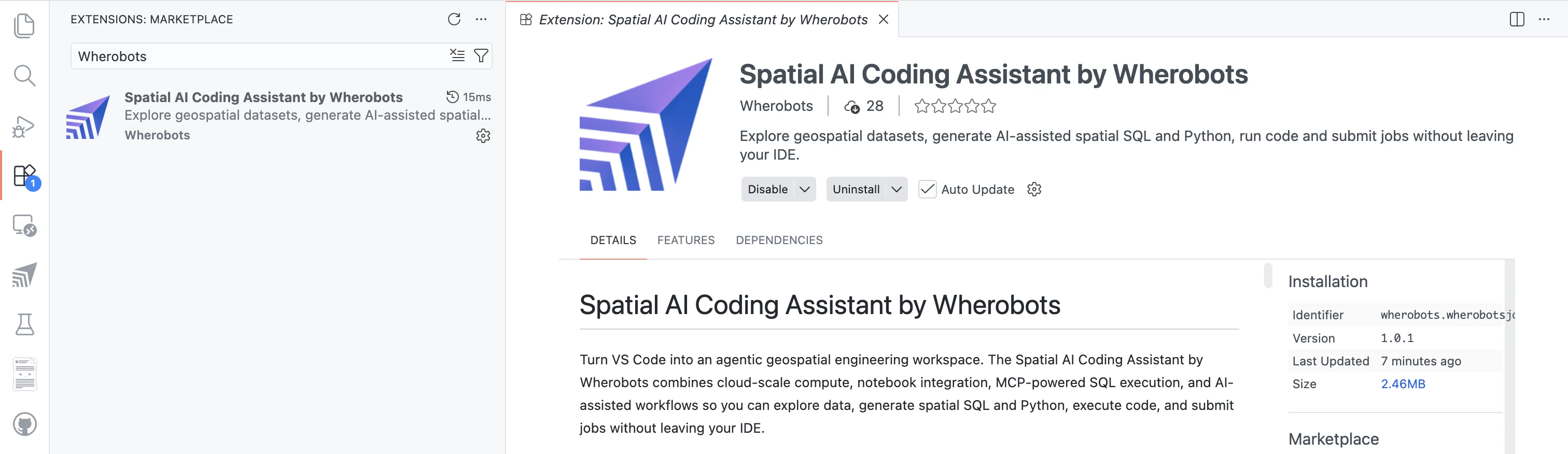
Wherobots VS Code Extension in the Visual Studio Marketplace
Install the extension from the command line
Install the extension by running one of the following commands in your terminal or by installing directly from the marketplace for your editor:Key capabilities
- Accelerated notebook development: Instead of starting from scratch, use Copilot to generate entire notebooks with natural language prompts.
- Run notebooks on Wherobots compute: Execute these generated notebooks using Wherobots compute, without leaving your editor.
- MCP-powered spatial Q&A: Query data catalogs and empower your AI assistants to execute spatial SQL and Python workflows via the automatically configured Wherobots MCP Server.
- Notebook lifecycle management: Create, start, stop, and manage workspaces from your editor’s sidebar, with access to the Spark UI and Jupyter URLs.
- Job submission: Submit
.pyfiles as cloud job runs with configurable runtime, region, timeout, and arguments — including inline job configuration via Python comments.
RasterFlow now available in Private Preview
Wherobots RasterFlow is an inference engine for large-scale raster processing and geospatial machine learning workflows.Build mosaics from multiple raster data sources, run inference with computer vision models, and vectorize results.RasterFlow Private Preview Access
RasterFlow Private Preview Access
RasterFlow is currently in Private Preview. Wherobots is rolling out RasterFlow to a select group of Organizations. If you are interested in gaining early access to these new capabilities and helping shape the future of the product, register your interest here.
Supported models
Currently, four pre-trained models are available in RasterFlow for different geospatial use cases: Fields of the World, Tile2Net, Meta CHM v1, and ChesapeakeRSC.We have created notebooks demonstrating how to use these models for real-world applications. Click the links below to try these notebooks out in Wherobots Cloud!
Agricultural Field Mapping
Detect field boundaries from Sentinel-2 imagery and segment crop fields across regions using the Fields of the World model

Urban Infrastructure Detection
Identify sidewalks, crosswalks, and pedestrian pathways from high-resolution aerial imagery using the Tile2Net model

Canopy Height Estimation
Predict tree canopy heights from aerial imagery to monitor forest health and vegetation structure using the Meta CHM v1 model

Rural Road Detection
Identify roads in rural environments and map road networks using the ChesapeakeRSC model
Key capabilities
- Planetary-scale processing: Process raster data at massive scale with optimized chunking, sharding, and parallel processing
- Simple, high-level API: Abstract away the complexity with pre-configured datasets and models—or bring your own
- Build mosaics: Combine multiple raster datasets into unified, analysis-ready mosaics
- Run model inference: Apply machine learning models to massive raster datasets at scale
- Vectorize results: Convert raster predictions into vector geometries for spatial analysis
Wherobots MCP Server now available for public preview
Transform your spatial data workflow with SQL generation available right inside VS Code!Focus on your analysis rather than syntax. With the Wherobots MCP Server, you can explore data catalogs and turn plain text descriptions into executable spatial SQL directly within your code editor.Key Features:- Natural Language Queries: Turn plain text descriptions into valid spatial SQL.
- Organization Access: Available for Professional and Enterprise Organizations. Usage is tracked as SQL Sessions in your Workload History.
- Integrated Workflow: Draft, execute, and iterate on your spatial SQL without leaving the VS Code environment.
- Quick Setup: Set up the MCP Server and get started in minutes.
- Usage Guide: Review the MCP Server usage guide for best practices, more example prompts, and cost considerations.
- “What catalogs are available in my Organization?”
- “What data sources should I use to analyze road networks in the US?”
- “Write a SQL query to find all burger restaurants within 5 miles of downtown San Francisco.”
Job Runs section is now Workload History
The Job Runs section in Wherobots Cloud has been renamed and expanded to Workload History, providing unified monitoring for all compute workloads across your Wherobots Organization.What’s new:- Unified view: Monitor Notebooks, SQL Sessions, and Job Runs in a single interface
- Enhanced filtering: Filter by time range, owner, region, and workload type
- Usage visualization: View quota consumption over time with an interactive chart
- Execution logs: Access detailed logs for debugging and troubleshooting directly in the UI with search, copy, and download capabilities
- Filter workloads by name, ID, owner, region, or type
- View detailed metrics including duration, CPU utilization, memory usage, cost, and Spatial Units consumed
- Access real-time execution logs with search functionality
- Compare performance across different runtime configurations
- Cancel running workloads directly from the interface
- View estimated costs and Spatial Units consumed for each workload
Spark 4.0 & Hadoop 3.4 Upgrade
This release introduces significant infrastructure upgrades to Spark 4.0 and Hadoop 3.4. Please review the breaking changes below to ensure workflow continuity.This functionality is exclusive to version 2.X of the runtime, which is currently in preview.To access these changes, you must enable the Preview WherobotsDB 2.0 checkbox in Wherobots Cloud when starting your notebook.
- ANSI SQL Enabled by Default: The default SQL model has changed to ANSI SQL.
- Action Required: Review and migrate existing SQL queries to ensure compliance with ANSI standards.
- Third-Party JAR Updates: Existing data source JARs may no longer be compatible.
- Action Required: Replace current jars with versions that support Spark 4.
- Hadoop JAR Updates: Third-party Hadoop libraries require updates.
- Action Required: Replace current jars with versions that support Hadoop 3.4.
WherobotsDB Introduces Spatial Support on Iceberg Views
WherobotsDB now provides spatial support for Apache Iceberg views, enabling you to leverage spatial functions and operations directly on view definitions.System Improvements and Performance Enhancements
This release includes general system improvements, performance enhancements, and backend stability updates. No breaking changes were introduced.Enhanced SSO Methods and Passkeys
We have overhauled our authentication system to provide more flexible and secure ways to access Wherobots Cloud.New login methods:- Google account login
- GitHub account login
- Passkeys: Register with passkeys for faster and more secure sign-in using device biometrics or screen lock
Action Required for SSO UsersIf you have previously configured Single Sign-On (SSO) for your organization, you must re-configure it following this update. Navigate to the Security page to set up SSO again.
Multi-Organization Support
A single user account can now belong to multiple Wherobots organizations with no limit on the number of organizations you can join or manage.Additionally, you can now change your first and last name within your user profile.Available in all editions: Community, Professional, and EnterpriseSystem Improvements and Performance Enhancements
This release includes general system improvements, performance enhancements, and backend stability updates. No breaking changes were introduced.New Functions: ST_ApproximateMedialAxis and ST_StraightSkeleton
We have introduced two new spatial SQL functions for advanced geometry processing:ST_ApproximateMedialAxis: Computes an approximate medial axis of polygonal geometries, useful for extracting skeletons from shapes, road centerlines, or river networks.ST_StraightSkeleton: Computes the straight skeleton or “centerline” of a polygon. This centerline is useful in roof modeling, map generalization, and shape analysis.
System Improvements and Performance Enhancements
This release includes general system improvements, performance enhancements, and backend stability updates. No breaking changes were introduced.System Improvements and Performance Enhancements
This release includes general system improvements, performance enhancements, and backend stability updates. No breaking changes were introduced.AWS ap-south-1 (Mumbai) Region Support
Paid Organizations can now deploy their Wherobots compute environments and manage resources within the AWSap-south-1 (Mumbai) region.Benefits:- Lower latency: Deploy closer to users, data sources, or endpoints in India and South Asia
- Architectural flexibility: Build geographically distributed applications for South Asia
Mumbai AWS Region Support is limited to Paid OrganizationsDeployment in the
ap-south-1 (Mumbai) region requires a Professional or Enterprise Organization. Community Edition is limited to us-west-2.System Improvements and Performance Enhancements
This release includes general system improvements, performance enhancements, and backend stability updates. No breaking changes were introduced.Data Federation for Databricks Unity Catalog
Customers can now securely connect Wherobots to their governed datasets in Unity Catalog within our Wherobots’ new Data Hub.With this capability, Paid Wherobots Organizations can connect their Unity Catalog tables to Wherobots high-performance compute and spatial ETL, without copying or moving data.Benefits:- Zero-Copy architecture: Read tables managed by Unity Catalog without moving or duplicating data
- Maintained governance: Databricks Workspace Admins retain catalog- and table-level access control
- Secure federation: Connect securely using Databricks authentication credentials
- Accelerated innovation: Use Wherobots’ 300+ spatial functions, raster inference, and compute on Unity Catalog data
- Direct Unity Catalog connection from Wherobots Data Hub
- Full read and write operations on Managed Iceberg tables
- Read access to Delta Lake tables
- Advanced Spatial analytics with 300+ spatial functions
Only Professional and Enterprise Edition Organizations can use the Databricks Unity Catalog Integration. Community Edition Organizations are limited to Wherobots-managed catalogs and open datasets.
System Improvements and Performance Enhancements
This release includes general system improvements, performance enhancements, and backend stability updates. No breaking changes were introduced.Enhanced Accuracy for ST_Transform
We’ve introduced an enhancement to theST_Transform function to significantly improve the accuracy of Coordinate Reference System (CRS) transformations.The ST_Transform function now includes an optional AOI (Area of Interest) parameter. By specifying an AOI, the transformation process uses a relevant subset of local grid files, resulting in more precise and reliable CRS transformations for your geospatial data.This is especially beneficial for large-scale and high-precision mapping applications.Example usage:1.11.1, 2.0.1-previewJuly 30, 2025
WherobotsDBBreaking Change
GeoTools Upgrade, Python Path Standardization, and WKB Writer Update (v1.11.0 / v2.0.1-preview)
GeoTools Upgrade, Python Path Standardization, and WKB Writer Update
This release introduces several significant updates. No workflow impact is expected, but please submit a bug report if you encounter any issues.Potentially Breaking Changes:- GeoTools Library Upgrade: The GeoTools library has been upgraded from
v28.5tov33.1. This could introduce changes in behavior forST_Transformand various raster functions. - Python Import Path Standardization: Python import paths under
sedona.XXXare now deprecated in favor ofsedona.spark.XXX. - WKB Writer Default Byte Order: The default WKB writer byte order has changed to little-endian. This change might affect GeoParquet files, Havasu-Iceberg tables, and
ST_AsWKBfunctions.
- Community Organizations: Share your feedback in the
#vendor-wherobotschannel on the Apache Sedona Discord. - Professional & Enterprise Organizations: Send feedback to support@wherobots.com.
1.11.0, 2.0.1-previewWherobotsDB 2.0 Preview
Accelerate common data operations such as filtering, aggregation, and join queries by up to 2x. Experience significantly faster and more efficient analysis of your non-spatial data, thanks to recent optimizations in our core engine.How to enable the preview:In Wherobots Cloud, select Preview WherobotsDB 2.0 when starting a runtime, or set theversion parameter to "preview" in Job Run and SQL Session API requests.We encourage you to enable the preview, run your typical workloads, and share your feedback with us.Version: 2.0.0-previewDekart Integration
Utilize Wherobots’ compute directly within Dekart, an open-source platform that quickly creates rich, interactive map visualizations from spatial SQL queries.Benefits:- Go from Spatial SQL to an interactive map in seconds
- Create up-to-date visualizations from large, dynamic datasets
- Avoid proprietary lock-in with open-source architecture
- Direct authentication with Wherobots API keys
- Query with Spatial SQL from Dekart interface
- Instant visualization with Kepler.gl maps
- Bring Your Own Data from AWS S3
Enhancing Isochrone and Reverse Geocoding
The backend data tables that power our isochrone and reverse geocoding functions have been updated to the latest versions from the Overture Maps Foundation.These tables will now automatically keep themselves up-to-date as new Overture data is released. This means your results will always be based on the freshest and most accurate global road network and place data available.Version:1.10.3New Address Parsing and Standardization Functions
This release introduces two powerful Spatial SQL functions for address data processing, based on thelibpostal library:ExpandAddress: Normalizes and expands address strings into their canonical forms (e.g., “st” becomes “street,” “apt” becomes “apartment”)ParseAddress: Breaks down a single address string into its individual components (house number, street, city, state, postcode)
1.10.2Hadoop Dependency Update
We have upgraded Wherobots’ Hadoop dependency from version3.3.4 to 3.3.6 to enhance platform stability and security.Version: 1.10.1Security Updates and Scala 2.13 Migration
This update focuses on enhancing the stability and security of the Wherobots Cloud platform.Breaking Change - Migration to Scala 2.13:To ensure future compatibility with Apache Spark 4, we’ve updated WherobotsDB’s Scala version from 2.12 to 2.13.Who is affected:- Customers who compile and deploy custom Scala applications or UDFs as
.jarfiles - Users of the Scala kernel for Scala notebooks
- Update your build environment to use a Scala
2.13.xcompiler - Update all dependencies from their
_2.12versions to their_2.13versions - Recompile your project to produce a new
.jarfile compatible with Scala 2.13
- Bug fixes for improved performance and reliability
- Dependency security updates with latest patches
1.10.0Stability and Security Enhancements
Bug fixes and dependency security updates to improve overall performance, reliability, and security of WherobotsDB.Version:1.9.2Vectorized Python UDFs and OSM Data Support
- New Feature: Added support for vectorized User Defined Functions (UDFs) in Python
- New Feature: Introduced a parser for OpenStreetMap (OSM) nodes data within the OSM PBF reader
- Improvement: Enhanced error messaging for invalid geometries during tile generation
1.9.0May 14, 2025
WherobotsDBPlatform UpdateBreaking Change
Java 17, GDAL 3.8.4, Spark 3.5.5 & Ubuntu 24.04 (v1.9.0)
Java 17, GDAL 3.8.4, Spark 3.5.5 & Ubuntu 24.04
Platform upgrades:- Operating System: Upgraded from Ubuntu 22.04 to 24.04 LTS
- GDAL: Upgraded from version 3.4.1 to 3.8.4
- Java: Standardized on Java 17 (LTS), moving from Java 19
- Spark: Updated from 3.5.4 to 3.5.5
- Java 17 (LTS): Custom code, UDFs, or JAR files compiled for Java 19 will need recompilation using Java 17 SDK
- GDAL 3.8.4: May alter behavior of certain geospatial functions. Review GDAL release notes for versions 3.5-3.8
1.9.0AWS us-east-1 (N. Virginia) Region Support
Paid Organizations can now deploy their Wherobots compute environments and manage resources within the AWSus-east-1 (N. Virginia) region.Benefits:- Lower Latency: Deploy closer to US East Coast users and data sources
- Optimized AWS Ecosystem Integration: Seamless integration with existing AWS resources in
us-east-1 - Data Residency & Compliance: Meet data residency requirements on the US East Coast
- Architectural Flexibility: Build geographically distributed applications
EU Region Support (AWS eu-west-1)
Our first compute region outside the United States! Workload capabilities are now available in AWSeu-west-1 (Ireland).Benefits:- Compliance: Run notebook compute resources within the EU to aid in meeting GDPR and data sovereignty requirements
- Latency Reduction: Potentially increase performance for data sources located in Europe
- Workflow Efficiency: Set a default EU region for new notebooks
- Notebooks, Job Runs, and SQL Sessions can run in
eu-west-1 - Default Region Preference for Admins
- Wherobots File System storage located within your selected region
EU Region Support is limited to Paid OrganizationsOnly Professional and Enterprise Edition Organizations can use
aws-eu-west-1. Community Edition Organizations are limited to AWS us-west-2.SAM2 Support in WherobotsAI Raster Inference
Wherobots is excited to announce enhancements to WherobotsAI Raster Inference, including the introduction of Text-Based Raster Detection & Segmentation.We’ve integrated support for Meta AI’s Segment Anything Model 2 (SAM2) and Google DeepMind’s OWLv2 models for text-prompted inference.New features:RS_Text_to_BBoxes: Text-prompted object detection returning bounding boxes, confidence scores, and labelsRS_Text_to_Segments: Text-prompted instance segmentation returning segmentation polygons, confidence scores, and labels
WherobotsAI Raster Inference Requires GPU Access
WherobotsAI Raster Inference Requires GPU Access
Access requires execution on GPU-Optimized runtimes within Wherobots Cloud. By default, GPU access is limited to Professional and Enterprise Edition Organizations who have requested and been granted access.Professional and Enterprise Organizations needing GPU access should submit a compute request to support@wherobots.com.
Audit Logs
Admins for Professional and Enterprise Organizations now have access to the Wherobots Audit Logs feature and its associated REST API endpoint.Benefits:- Enhanced Security: Monitor key activities to identify potential security risks
- Improved Accountability: Track user actions and system events
- Operational Transparency: Gain insights into resource usage
- Data Retention: Use the API to preserve logs beyond Wherobots’ 90-day retention period
- Comprehensive activity tracking across security, files, jobs, notebooks, organization, data, and runtimes
- Intuitive UI with flexible filtering
- On-demand CSV export from UI
- Programmatic export via REST API
- Admin-only access
Travel Isochrones Functionality and Dataset
Professional and Enterprise Organizations now have access toST_Isochrone and ST_Isochrones for generating travel time isochrones.We’re also releasing the Overture Places with Isochrones dataset, which augments the original Overture Places dataset with columns defining the 5, 10, 15, and 20-minute travel time boundaries from each of 13.3 million US Places.New Features:ST_Isochrone: Generate a single polygon representing the reachable area within a specified timeST_Isochrones: Generate an array of polygons for multiple time limits- Dataset Enrichment: Overture Places enriched with 4 new isochrone geometry columns
Limited to Paid Organizations
Limited to Paid Organizations
Only Professional and Enterprise Edition Organizations have access to
ST_Isochrone, ST_Isochrones, and the Overture Places with Isochrones dataset.Job Run Monitoring
Wherobots Cloud now provides integrated visualizations for Job Runs, allowing you to monitor Job Run execution, resource usage, and configuration directly in the Wherobots Cloud platform for Paid Organization Tiers.Key Features:- Job Runs Summary View with status, trigger, duration, and details
- Detailed information including consumption metrics (Spatial Units, CPU, Memory)
- Filtering capabilities by name
- Job Run cancellation directly from the UI
- Configuration information display
Idle Timeout for Notebooks
Wherobots Cloud has a new Idle Timeout feature to help you better manage your notebook runtime resources and optimize costs.Key Features:- Customizable Timeout: Select 15 minutes, 45 minutes (default), or 120 minutes
- Persistent User Settings: Your chosen setting is saved across sessions
- Automatic Kernel Termination: Jupyter kernel terminates after idle period
- Notebook Instance Specific: Only applies to Notebook Instances, not Job Runs
STAC Reader for Wherobots
The new STAC Reader data source loads STAC (SpatioTemporal Asset Catalog) items and collections directly into Sedona DataFrames.Benefits:- Direct STAC Integration: Access STAC-compliant catalogs directly in Wherobots workflows
- Performance Optimization: Spatial and Temporal Filter Pushdown reduces data transfer and processing
- Flexible Data Access: Connect via HTTP/HTTPS endpoint, S3-compatible object store, or local JSON file
1.4 - A Major Leap Forward for Wherobots
Wherobots 1.4 delivers significant advancements with a host of new features for WherobotsDB and WherobotsAI.Key Features:Amazon S3 Integration: Accelerate spatial data product creation by using data directly from Amazon S3 public or private buckets, bypassing time-consuming data transfers.Job Run Automation with Airflow: Integrate Wherobots’ geospatial processing into your Airflow workflows using the
WherobotsRunOperator.WherobotsAI Raster Inference: Uses computer vision to gather insights from raster data at planetary scale (requires GPU-Optimized runtime for Paid Organizations).AWS Marketplace Listing: Create a new Professional Organization or upgrade through the AWS Marketplace.Long-lived Token Management: Professional Edition Organization Administrators can use service principals for API authentication through long-lived tokens.Wherobots 1.3
This major release includes:WherobotsDB - A scalable spatial analytics database system:- Spatial query engine: compatible with Apache Sedona
- Havasu Iceberg data lake storage layer: compatible with Apache Iceberg
- Vtiles: a scalable PMTiles-style vector tile generator
- Raster inference: a scalable raster inference engine in SQL and Python
- Map matching: a scalable map matcher for snapping massive GPS traces to the road network
Wherobots 1.2
This major release includes:WherobotsDB - A scalable spatial analytics database system, powered by Havasu data lake format:- Spatial query engine: compatible with Apache Sedona
- Havasu Iceberg data lake storage layer: compatible with Apache Iceberg