> ## Documentation Index
> Fetch the complete documentation index at: https://docs.wherobots.com/llms.txt
> Use this file to discover all available pages before exploring further.
# Get Started with RasterFlow
> Scale raster processing and geospatial machine learning workflows with Wherobots RasterFlow. An overview of RasterFlow, its features, and how to get started.
Private Preview
Get started running RasterFlow in Wherobots.
Browse the RasterFlow API documentation
Learn about built-in datasets and how to bring your own.
Learn about built-in models and how to bring your own.
Submit RasterFlow workflows as automated Job Runs.
RasterFlow replaces the previous Raster Inference feature. For more information, see the [changelog](/changelog).
Wherobots RasterFlow is a powerful inference engine for large-scale raster processing and inferencing.
It enables you to build mosaics from multiple raster data sources, run inference with computer vision models, and vectorize results—all with a simple, high-level API.
## Why choose RasterFlow?
RasterFlow provides a managed workflow execution environment for geospatial raster processing tasks. It abstracts away the complexity of raster pipelines and distributed computing, allowing you to focus on your analysis rather than data engineering and infrastructure management.
Key capabilities include:
Process raster data at massive scale with optimized chunking, sharding, and parallel processing
Abstract away the complexity with pre-configured datasets and models—or bring your own
Combine multiple raster datasets into unified, analysis-ready mosaics
Apply machine learning models to massive raster datasets at scale
Convert raster predictions into vector geometries for spatial analysis
Build flexible pipelines with your own data, models, and processing parameters
Work with GeoTIFF, Zarr, and GeoParquet formats
## Key concepts
The following concepts are fundamental to understanding how RasterFlow works:
Mosaics are spatially-aligned raster datasets stored in Zarr format. RasterFlow can build mosaics from aerial and satellite imagery to prepare them for model inference. This process can combine one or more datasets across an Area of Interest (AOI) and a temporal dimension to create a single seamless input mosaic for inference.
RasterFlow has workflows for building mosaics from the [built-in datasets](https://docs.wherobots.com/reference/rasterflow/client#build-mosaic) or [your own imagery](https://docs.wherobots.com/reference/rasterflow/client#build-gti-mosaic).
Run computer vision models on raster data at scale:
* **Semantic Segmentation**: Classify each pixel (e.g., land cover mapping)
* **Regression**: Predict continuous values (e.g., canopy height estimation in meters)
* **Patch-based Processing**: Handle large mosaics by dividing into manageable patches
Convert raster predictions to vector geometries:
* **Threshold-based**: Binarize continuous predictions
* **Polygonization**: Create polygon features from classified pixels
* **Coordinate transformation**: Reproject to desired CRS (e.g., WGS84)
## Choosing a runtime size
RasterFlow manages its own compute resources for raster processing, so the [Wherobots Runtime size](/develop/runtimes/) you select does not affect RasterFlow workflow performance. You should generally use the **Micro** runtime for RasterFlow workloads to minimize cost.
The only exception is if you plan to also perform vector processing with WherobotsDB (e.g., using SedonaContext for spatial SQL queries) in the same job or notebook session. In that case, choose a runtime size appropriate for your WherobotsDB workload — the RasterFlow portions of the workflow will still be unaffected by the runtime size selection.
## Get started
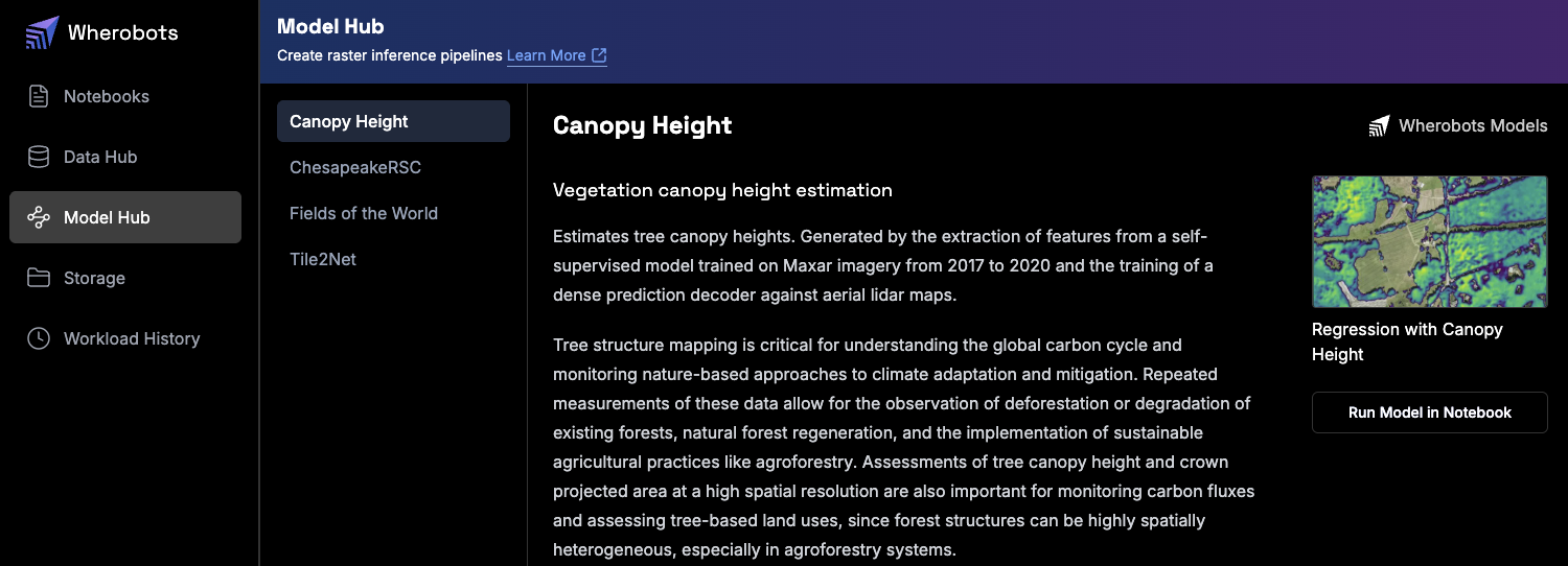
To get started, login to Wherobots Cloud and try out one of the built-in models by running a RasterFlow notebook in the [**Model Hub**](https://cloud.wherobots.com/model-hub).
 Detect field boundaries from Sentinel-2 imagery and segment crop fields across regions using the Fields of the World model
Identify sidewalks, crosswalks, and pedestrian pathways from high-resolution aerial imagery using the Tile2Net model
Predict tree canopy heights from aerial imagery to monitor forest health and vegetation structure using the Meta CHM v1 model
Identify roads in rural environments and map road networks using the ChesapeakeRSC model
RasterFlow is currently in Private Preview. Wherobots is rolling out RasterFlow to a select group of Organizations. If you are interested in gaining early access to these new capabilities and helping shape the future of the product, [register your interest here](https://wherobots.com/rasterflow-preview/).
The examples below demonstrate real-world applications that you can adapt to your own data and use cases. Each notebook provides a complete, working implementation to help you get started quickly.
| **Use Case** | **Capabilities** | **Example Application** | **Notebook** |
| ---------------------------------- | ----------------------------------------------------------------------------------------------------------------------------------------------------------------------------- | ---------------------------------------------------------------------------------------------------------------- | ------------------------------------------------------------------------------------------------- |
| **Agricultural Field Mapping** | - Detect field boundaries from Sentinel-2 imagery
Detect field boundaries from Sentinel-2 imagery and segment crop fields across regions using the Fields of the World model
Identify sidewalks, crosswalks, and pedestrian pathways from high-resolution aerial imagery using the Tile2Net model
Predict tree canopy heights from aerial imagery to monitor forest health and vegetation structure using the Meta CHM v1 model
Identify roads in rural environments and map road networks using the ChesapeakeRSC model
RasterFlow is currently in Private Preview. Wherobots is rolling out RasterFlow to a select group of Organizations. If you are interested in gaining early access to these new capabilities and helping shape the future of the product, [register your interest here](https://wherobots.com/rasterflow-preview/).
The examples below demonstrate real-world applications that you can adapt to your own data and use cases. Each notebook provides a complete, working implementation to help you get started quickly.
| **Use Case** | **Capabilities** | **Example Application** | **Notebook** |
| ---------------------------------- | ----------------------------------------------------------------------------------------------------------------------------------------------------------------------------- | ---------------------------------------------------------------------------------------------------------------- | ------------------------------------------------------------------------------------------------- |
| **Agricultural Field Mapping** | - Detect field boundaries from Sentinel-2 imagery
- Segment crop fields across counties/regions
- Convert raster predictions to vector geometries | Map all agricultural fields in Haskell County, Kansas using Sentinel-2 imagery and the Fields of the World model | [Try the Fields of the World notebook](https://cloud.wherobots.com/model-hub/fields-of-the-world) |
| **Urban Infrastructure Detection** | - Identify sidewalks, crosswalks, and pedestrian pathways
- Generate detailed maps for urban planning
- Analyze accessibility from high-resolution aerial imagery | Detect and map sidewalk networks in College Park, Maryland using 30cm NAIP imagery with the Tile2Net model | [Try the Tile2Net notebook](https://cloud.wherobots.com/model-hub/tile2net) |
| **Canopy Height Estimation** | - Predict tree canopy heights from aerial imagery
- Monitor forest health and vegetation structure
- Support conservation and urban forestry initiatives | Estimate tree heights across Nashua, NH using 60cm NAIP imagery with the Meta CHM v1 model | [Try the Meta CHM v1 notebook](https://cloud.wherobots.com/model-hub/canopy-height) |
| **Rural Road Detection** | - Identify roads, especially in rural environments
- Map road networks to support routing and navigation
- Detect road network changes to keep maps up to date | Detect roads in Maryland using 1m NAIP imagery with the ChesapeakeRSC model | [Try the ChesapeakeRSC notebook](https://cloud.wherobots.com/model-hub/chesapeake-rsc) |
## Next steps
* Try out the pre-configured model solutions notebooks in the [**Model Hub**](https://cloud.wherobots.com/model-hub) in Wherobots Cloud
* [Run RasterFlow as a Job](/develop/rasterflow/rasterflow-jobs) for automated, production-scale processing
* Explore the [Client API Reference](/reference/rasterflow) to learn about all available methods
* Review [Data Models](/reference/rasterflow/data-models) to understand configuration options
## API reference
For detailed API documentation, see:
* [Client API Reference](/reference/rasterflow/client) - `RasterflowClient` methods
* [Data Models Reference](/reference/rasterflow/data-models) - Enums and configuration objects
* [Model Registry Reference](/reference/rasterflow/model-registry) - Working with model registries
* [Exceptions Reference](/reference/rasterflow/exceptions) - Error handling